Remote Sensing
Forest Growers Research Annual Conference
October 17-19 2017
1. Industry applications of UAVs
2. Summary of Remote Sensing projects at Scion
3. Remote sensing adoption within the forest industry
1. Industry applications of UAVs
Conference presenter: Dr Grant Pearse
Presentation: UAV Applications for Commercial Forestry
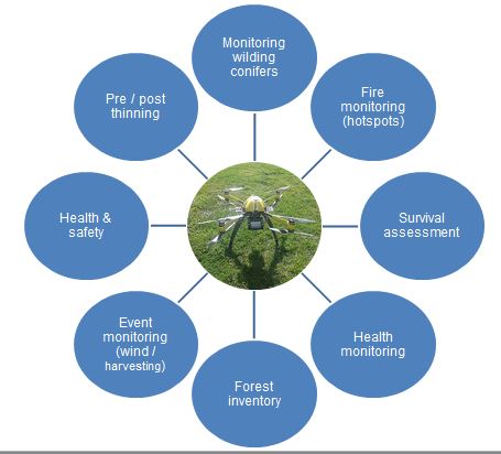
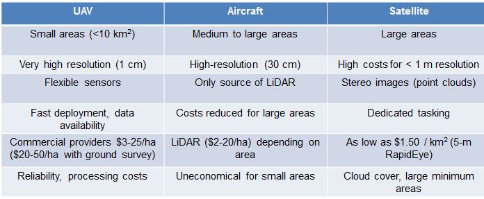
As part of a project to understand the roles and cost-efficacy of using UAVs as opposed to other remote sensing technology, four potential applications of UAVs in forestry were assessed recently by Scion,
- Detecting wind damage
- Mapping cutover areas
- Assessing post-planting survival
- Assessing post-harvest waste
The project focussed on using accessible data and readily available tools where possible to make it as relevant as possible to the forest industry. The conclusion reached was that UAVs can undertake all these tasks well and be effective. They also have their own niche, complimenting rather than displacing other remote sensing methods.
Summary: Where do UAVs fit in forestry?
2. Summary of remote sensing projects at Scion
Conference presenter: Dr Michael Watt – Scion
Presentation and Video: Summary of Remote Sensing Projects
Scion’s remit is to provide remote sensing research that adds value to the forest sector and to New Zealand. Scion’s geomatics scientists are an integral part of research teams, covering many aspects of forest management and health.
Applications of remote sensing in the past two years
- Detect wilding conifers – wildings can now be identified using a combination of LiDAR and spectral data
- Detect stream locations within a watershed using LiDAR (although validation is required)
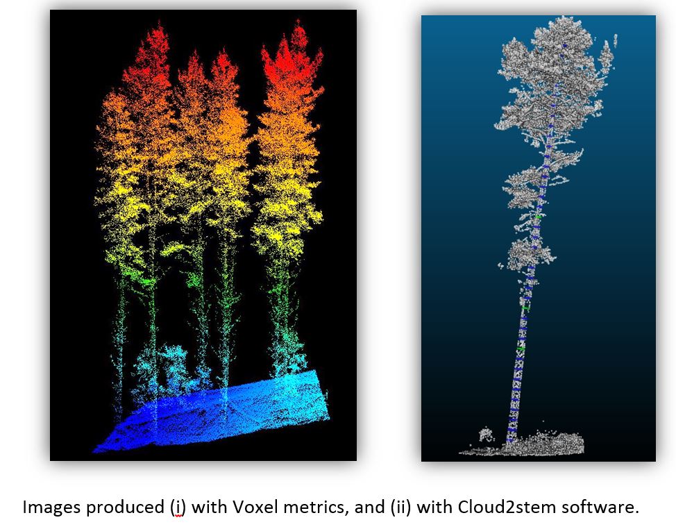
- Develop a set of ‘Voxel’ metrics that can be used to increase inventory accuracy over standard LiDAR metrics.
- New point clouds using Cloud2stem software will soon be able to accurately measure stem diameters.
- Identify needle mortality (and hence disease symptoms) using a UAV – this research involved simulating a disease outbreak by poisoning some trees so that changes in needle colour and foliar retention could be analysed.
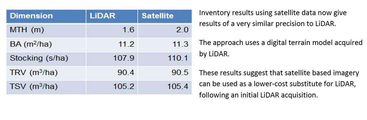
- Prove that satellite data can be an inexpensive and equally accurate alternative to LiDAR for inventory.
3. Remote sensing adoption within the forest industry
Conference presenter: David Herries, Interpine
Presentation and Video: Commercialisation of Remote Sensing for Forest Owners
Interpine are New Zealand’s largest UAV service provider, and are already using UAV’s for a whole suite of forest management activities. Examples include:
- equipment inspections, harvest waste assessment and monitoring of sensitive zones on harvest sites
- land preparation assessments including digital terrain mapping e.g. for road-planning
- new planting inspections/quality control
- nursery stocktakes
- trial monitoring.
Drones are also playing a vital role in fire-fighting, including the February 2017 Port Hills fire. During this fire, Interpine’s drones were fitted with infra-red heat sensors and were flown at night. Their job was to locate and geo-reference hotspots. The information was delivered to fire fighters by day-break via a mobile phone app, enabling them to go directly to the hotspots and deal with them, saving valuable hours on the ground.
UAVs role is seen as providing ‘another set of eyes’ for forest managers, with ever-increasing capabilities to measure, count and monitor different elements of the forest and forest operations. Forest management companies are advised to identify a member of staff – a ‘champion’ – and invest in training and running some trials with this person. Also important is that operating policies and procedures are developed, and the law relating to use of UAVs is well understood.
ENDS